|
| |
| The World Factbook |
|
|
American Samoa |
|
| Introduction |
American Samoa |
|
Background:
|
Settled as early as 1000 B.C., Samoa was "discovered" by European explorers in the 18th century. International rivalries in the latter half of the 19th century were settled by an 1899 treaty in which Germany and the US divided the Samoan archipelago. The US formally occupied its portion - a smaller group of eastern islands with the excellent harbor of Pago Pago - the following year.
|
|
Location:
|
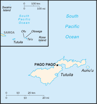
Oceania, group of islands in the South Pacific Ocean, about half way between Hawaii and New Zealand
|
|
Geographic coordinates:
|
14 20 S, 170 00 W
|
|
Map references:
|
Oceania
|
|
Area:
|
total: 199 sq km
land: 199 sq km
water: 0 sq km
note: includes Rose Island and Swains Island
|
|
Area - comparative:
|
slightly larger than Washington, DC
|
|
Land boundaries:
|
0 km
|
|
Coastline:
|
116 km
|
|
Maritime claims:
|
territorial sea: 12 nm
exclusive economic zone: 200 nm
|
|
Climate:
|
tropical marine, moderated by southeast trade winds; annual rainfall averages about 3 m; rainy season (November to April), dry season (May to October); little seasonal temperature variation
|
|
Terrain:
|
five volcanic islands with rugged peaks and limited coastal plains, two coral atolls (Rose Island, Swains Island)
|
|
Elevation extremes:
|
lowest point: Pacific Ocean 0 m
highest point: Lata Mountain 964 m
|
|
Natural resources:
|
pumice, pumicite
|
|
Land use:
|
arable land: 10%
permanent crops: 15%
other: 75% (2005)
|
|
Irrigated land:
|
NA
|
|
Natural hazards:
|
typhoons common from December to March
|
|
Environment - current issues:
|
limited natural fresh water resources; the water division of the government has spent substantial funds in the past few years to improve water catchments and pipelines
|
|
Geography - note:
|
Pago Pago has one of the best natural deepwater harbors in the South Pacific Ocean, sheltered by shape from rough seas and protected by peripheral mountains from high winds; strategic location in the South Pacific Ocean
|
|
Population:
|
64,827 (July 2008 est.)
|
|
Age structure:
|
0-14 years: 34.4% (male 11,337/female 10,946)
15-64 years: 61.8% (male 20,335/female 19,728)
65 years and over: 3.8% (male 1,161/female 1,320) (2008 est.)
|
|
Median age:
|
total: 22.8 years
male: 22.7 years
female: 23 years (2008 est.)
|
|
Population growth rate:
|
1.236% (2008 est.)
|
|
Birth rate:
|
23.66 births/1,000 population (2008 est.)
|
|
Death rate:
|
4.13 deaths/1,000 population (2008 est.)
|
|
Net migration rate:
|
-7.17 migrant(s)/1,000 population (2008 est.)
|
|
Sex ratio:
|
at birth: 1.06 male(s)/female
under 15 years: 1.04 male(s)/female
15-64 years: 1.03 male(s)/female
65 years and over: 0.88 male(s)/female
total population: 0.995 male(s)/female (2008 est.)
|
|
Infant mortality rate:
|
total: 10.46 deaths/1,000 live births
male: 13.69 deaths/1,000 live births
female: 7.03 deaths/1,000 live births (2008 est.)
|
|
Life expectancy at birth:
|
total population: 73.47 years
male: 70.55 years
female: 76.56 years (2008 est.)
|
|
Total fertility rate:
|
3.35 children born/woman (2008 est.)
|
|
HIV/AIDS - adult prevalence rate:
|
NA
|
|
HIV/AIDS - people living with HIV/AIDS:
|
NA
|
|
HIV/AIDS - deaths:
|
NA
|
|
Nationality:
|
noun: American Samoan(s) (US nationals)
adjective: American Samoan
|
|
Ethnic groups:
|
native Pacific islander 91.6%, Asian 2.8%, white 1.1%, mixed 4.2%, other 0.3% (2000 census)
|
|
Religions:
|
Christian Congregationalist 50%, Roman Catholic 20%, Protestant and other 30%
|
|
Languages:
|
Samoan 90.6% (closely related to Hawaiian and other Polynesian languages), English 2.9%, Tongan 2.4%, other Pacific islander 2.1%, other 2%
note: most people are bilingual (2000 census)
|
|
Literacy:
|
definition: age 15 and over can read and write
total population: 97%
male: 98%
female: 97% (1980 est.)
|
|
Education expenditures:
|
NA
|
| Government |
American Samoa |
|
Country name:
|
conventional long form: Territory of American Samoa
conventional short form: American Samoa
abbreviation: AS
|
|
Dependency status:
|
unincorporated and unorganized territory of the US; administered by the Office of Insular Affairs, US Department of the Interior
|
|
Government type:
|
NA
|
|
Capital:
|
name: Pago Pago
geographic coordinates: 14 16 S, 170 42 W
time difference: UTC-11 (6 hours behind Washington, DC during Standard Time)
|
|
Administrative divisions:
|
none (territory of the US); there are no first-order administrative divisions as defined by the US Government, but there are three districts and two islands* at the second order; Eastern, Manu'a, Rose Island*, Swains Island*, Western
|
|
Independence:
|
none (territory of the US)
|
|
National holiday:
|
Flag Day, 17 April (1900)
|
|
Constitution:
|
ratified 2 June 1966, effective 1 July 1967
|
|
Legal system:
|
NA
|
|
Suffrage:
|
18 years of age; universal
|
|
Executive branch:
|
chief of state: President George W. BUSH of the US (since 20 January 2001); Vice President Richard B. CHENEY (since 20 January 2001)
head of government: Governor Togiola TULAFONO (since 7 April 2003)
cabinet: Cabinet made up of 12 department directors
elections: under the US Constitution, residents of unincorporated territories, such as American Samoa, do not vote in elections for US president and vice president; however, they may vote in Democratic and Republican presidential primary elections; governor and lieutenant governor elected on the same ticket by popular vote for four-year terms (eligible for a second term); election last held 2 and 16 November 2004 (next to be held in November 2008)
election results: Togiola TULAFONO elected governor; percent of vote - Togiola TULAFONO 55.7%, Afoa Moega LUTU 44.3%
|
|
Legislative branch:
|
bicameral Fono or Legislative Assembly consists of the House of Representatives (21 seats; 20 members are elected by popular vote and 1 is an appointed, nonvoting delegate from Swains Island; members serve two-year terms) and the Senate (18 seats; members are elected from local chiefs to serve four-year terms)
elections: House of Representatives - last held 7 November 2006 (next to be held in November 2008); Senate - last held 2 November 2004 (next to be held in November 2008)
election results: House of Representatives - percent of vote by party - NA; seats by party - NA; Senate - percent of vote by party - NA; seats by party - independents 18
note: American Samoa elects one nonvoting representative to the US House of Representatives; election last held on 7 November 2006 (next to be held in November 2008); results - Eni F. H. FALEOMAVAEGA reelected as delegate
|
|
Judicial branch:
|
High Court (chief justice and associate justices are appointed by the US Secretary of the Interior)
|
|
Political parties and leaders:
|
Democratic Party [Oreta M. TOGAFAU]; Republican Party [Tautai A. F. FAALEVAO]
|
|
Political pressure groups and leaders:
|
Population Pressure LAS (addresses the growing population pressures)
|
|
International organization participation:
|
Interpol (subbureau), IOC, SPC, UPU
|
|
Diplomatic representation in the US:
|
none (territory of the US)
|
|
Diplomatic representation from the US:
|
none (territory of the US)
|
|
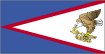
Flag description:
|
blue, with a white triangle edged in red that is based on the fly side and extends to the hoist side; a brown and white American bald eagle flying toward the hoist side is carrying two traditional Samoan symbols of authority, a war club known as a "Fa'alaufa'i" (upper; left talon), and a coconut fiber fly whisk known as a "Fue" (lower; right talon); the combination of symbols broadly mimics that seen on the US Great Seal and reflects the relationship between the United States and American Samoa
|
|
Economy - overview:
|
American Samoa has a traditional Polynesian economy in which more than 90% of the land is communally owned. Economic activity is strongly linked to the US with which American Samoa conducts most of its commerce. Tuna fishing and tuna processing plants are the backbone of the private sector, with canned tuna the primary export. Transfers from the US Government add substantially to American Samoa's economic well being. Attempts by the government to develop a larger and broader economy are restrained by Samoa's remote location, its limited transportation, and its devastating hurricanes. Tourism is a promising developing sector.
note: as a territory of the US, American Samoa does not treat the US as an external trade partner
|
|
GDP (purchasing power parity):
|
$510.1 million (2003 est.)
|
|
GDP (official exchange rate):
|
$333.8 million (2005)
|
|
GDP - real growth rate:
|
3% (2003 est.)
|
|
GDP - per capita (PPP):
|
$5,800 (2005 est.)
|
|
GDP - composition by sector:
|
agriculture: NA%
industry: NA%
services: NA%
|
|
Labor force:
|
17,630 (2005)
|
|
Labor force - by occupation:
|
agriculture: 34%
industry: 33%
services: 33% (1990)
|
|
Unemployment rate:
|
29.8% (2005)
|
|
Population below poverty line:
|
NA%
|
|
Household income or consumption by percentage share:
|
lowest 10%: NA%
highest 10%: NA%
|
|
Inflation rate (consumer prices):
|
NA%
|
|
Budget:
|
revenues: $121 million (37% in local revenue and 63% in US grants)
expenditures: $127 million (FY96/97)
|
|
Agriculture - products:
|
bananas, coconuts, vegetables, taro, breadfruit, yams, copra, pineapples, papayas; dairy products, livestock
|
|
Industries:
|
tuna canneries (largely supplied by foreign fishing vessels), handicrafts
|
|
Industrial production growth rate:
|
NA%
|
|
Electricity - production:
|
180 million kWh (2005)
|
|
Electricity - production by source:
|
fossil fuel: 100%
hydro: 0%
nuclear: 0%
other: 0% (2001)
|
|
Electricity - consumption:
|
167.4 million kWh (2005)
|
|
Electricity - exports:
|
0 kWh (2005)
|
|
Electricity - imports:
|
0 kWh (2005)
|
|
Oil - production:
|
0 bbl/day (2005)
|
|
Oil - consumption:
|
4,000 bbl/day (2005 est.)
|
|
Oil - exports:
|
0 bbl/day (2004)
|
|
Oil - imports:
|
3,807 bbl/day (2004)
|
|
Oil - proved reserves:
|
0 bbl (1 January 2006 est.)
|
|
Natural gas - production:
|
0 cu m (2005 est.)
|
|
Natural gas - consumption:
|
0 cu m (2005 est.)
|
|
Natural gas - exports:
|
0 cu m (2005 est.)
|
|
Natural gas - imports:
|
0 cu m (2005)
|
|
Natural gas - proved reserves:
|
0 cu m (1 January 2006 est.)
|
|
Exports:
|
$445.6 million (FY04 est.)
|
|
Exports - commodities:
|
canned tuna 93% (2004 est.)
|
|
Exports - partners:
|
Indonesia 28.2%, India 22.3%, Australia 15.3%, Japan 11.2%, NZ 7.1% (2006)
|
|
Imports:
|
$308.8 million (FY04 est.)
|
|
Imports - commodities:
|
materials for canneries 56%, food 8%, petroleum products 7%, machinery and parts 6% (2004 est.)
|
|
Imports - partners:
|
Australia 66%, Samoa 13.8%, NZ 10.8% (2006)
|
|
Economic aid - recipient:
|
important financial support from the US, more than $40 million in 1994
|
|
Debt - external:
|
$NA
|
|
Currency (code):
|
US dollar (USD)
|
|
Currency code:
|
USD
|
|
Exchange rates:
|
the US dollar is used
|
|
Fiscal year:
|
1 October - 30 September
|
| Communications |
American Samoa |
|
Telephones - main lines in use:
|
10,400 (2004)
|
|
Telephones - mobile cellular:
|
2,200 (2004)
|
|
Telephone system:
|
general assessment: NA
domestic: good telex, telegraph, facsimile, and cellular telephone services; domestic satellite system with 1 Comsat earth station
international: country code - 1-684; satellite earth station - 1 (Intelsat-Pacific Ocean)
|
|
Radio broadcast stations:
|
AM 2, FM 3, shortwave 0 (2005)
|
|
Radios:
|
57,000 (1997)
|
|
Television broadcast stations:
|
1 (2006)
|
|
Televisions:
|
14,000 (1997)
|
|
Internet country code:
|
.as
|
|
Internet hosts:
|
1,824 (2007)
|
|
Internet Service Providers (ISPs):
|
1 (2000)
|
|
Internet users:
|
NA
|
| Transportation |
American Samoa |
|
Airports:
|
3 (2007)
|
|
Airports - with paved runways:
|
total: 3
over 3,047 m: 1
914 to 1,523 m: 1
under 914 m: 1 (2007)
|
|
Roadways:
|
total: 185 km (2004)
|
|
Ports and terminals:
|
Pago Pago
|
|
Military - note:
|
defense is the responsibility of the US
|
| Transnational Issues |
American Samoa |
|
Disputes - international:
|
Tokelau periodically asserts claims to American Samoa's Swains Island (Olohega), such as in its 2006 draft independence constitution
|
|
This page was last updated on 4 September, 2008
|
| | Source : The World Factbook |
| |
|