|
|
|
| |
| The World Factbook |
|
|
Akrotiri |
|
|
Background:
|
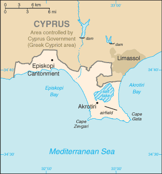
By terms of the 1960 Treaty of Establishment that created the independent Republic of Cyprus, the UK retained full sovereignty and jurisdiction over two areas of almost 254 square kilometers - Akrotiri and Dhekelia. The southernmost and smallest of these is the Akrotiri Sovereign Base Area, which is also referred to as the Western Sovereign Base Area.
|
|
Location:
|
Eastern Mediterranean, peninsula on the southwest coast of Cyprus
|
|
Geographic coordinates:
|
34 37 N, 32 58 E
|
|
Map references:
|
Middle East
|
|
Area:
|
total: 123 sq km
note: includes a salt lake and wetlands
|
|
Area - comparative:
|
about 0.7 times the size of Washington, DC
|
|
Land boundaries:
|
total: 47.4 km
border countries: Cyprus 47.4 km
|
|
Coastline:
|
56.3 km
|
|
Climate:
|
temperate; Mediterranean with hot, dry summers and cool winters
|
|
Environment - current issues:
|
shooting around the salt lake; note - breeding place for loggerhead and green turtles; only remaining colony of griffon vultures is on the base
|
|
Geography - note:
|
British extraterritorial rights also extended to several small off-post sites scattered across Cyprus; of the Sovereign Base Area land, 60% is privately owned and farmed, 20% is owned by the Ministry of Defense, and 20% is SBA Crown land
|
|
Population:
|
approximately 15,700 live on the Sovereign Base Areas of Akrotiri and Dhekelia including 7,700 Cypriots, 3,600 Service and UK-based contract personnel, and 4,400 dependents
|
|
Languages:
|
English, Greek
|
|
Country name:
|
conventional long form: Akrotiri Sovereign Base Area
conventional short form: Akrotiri
|
|
Dependency status:
|
a special form of UK overseas territory; administered by an administrator who is also the Commander, British Forces Cyprus
|
|
Capital:
|
name: Episkopi Cantonment (base administrative center for Akrotiri and Dhekelia)
geographic coordinates: 34 40 N, 32 51 E
time difference: UTC+2 (7 hours ahead of Washington, DC during Standard Time)
daylight saving time: +1hr, begins last Sunday in March; ends last Sunday in October
|
|
Constitution:
|
Sovereign Base Areas of Akrotiri and Dhekelia Order in Council 1960, effective 16 August 1960, functions as a basic legal document
|
|
Legal system:
|
the Sovereign Base Area Administration has its own court system to deal with civil and criminal matters; laws applicable to the Cypriot population are, as far as possible, the same as the laws of the Republic of Cyprus
|
|
Executive branch:
|
chief of state: Queen ELIZABETH II (since 6 February 1952)
head of government: Administrator Air Vice-Marshal Richard LACEY (since 26 April 2006); note - reports to the British Ministry of Defense
elections: none; the monarch is hereditary; the administrator is appointed by the monarch
|
|
Diplomatic representation in the US:
|
none (overseas territory of the UK)
|
|
Diplomatic representation from the US:
|
none (overseas territory of the UK)
|
|
Flag description:
|
the flag of the UK is used
|
|
Economy - overview:
|
Economic activity is limited to providing services to the military and their families located in Akrotiri. All food and manufactured goods must be imported.
|
|
Currency (code):
|
euro (EUR) adopted 1 January 2008; note - the Cypriot pound (CYP) formerly used
|
|
Exchange rates:
|
Cypriot pounds per US dollar - 0.4286 (2007), 0.46019 (2006), 0.4641 (2005), 0.4686 (2004), 0.5174 (2003)
|
|
Radio broadcast stations:
|
AM NA, FM 1, shortwave NA (British Forces Broadcasting Service (BFBS) provides Radio 1 and Radio 2 service to Akrotiri, Dhekelia, and Nicosia) (2006)
|
|
Television broadcast stations:
|
0 (British Forces Broadcasting Service (BFBS) provides multi-channel satellite service to Akrotiri, Dhekelia, and Nicosia) (2006)
|
|
Military - note:
|
Akrotiri has a full RAF base, Headquarters for British Forces on Cyprus, and Episkopi Support Unit
|
|
This page was last updated on 4 September, 2008
|
| | Source : The World Factbook |
| |
|
|
|
|
|
|
|